The Archaeological Survey of Ireland which is part of the National Monument Service maintains and updates an inventory of archaeological monuments. This is available online at this link. Full descriptions of the monuments recorded within the Park are available from the Sites and Monuments Archive of the National Monuments Service.
Prehistory
Prior to its enclosure as a deer park, the Phoenix Park was an occupied landscape. People lived here, worked here, moved through and across the park, died and were buried here. From the Neolithic period onwards, from about 5,500 years ago, signs of human activity are notable on the narrow, high strip of land which forms the southern edge to the Phoenix Park between Knockmaroon and Islandbridge. Ancient peoples may have been drawn to the commanding position of lands overlooking the River Liffey and to the panoramic views across the river valley to the Dublin mountains.
Evidence for Neolithic and Bronze Age populations is illustrated by the construction and usage of a cemetery mound known as “Knockmary” deriving its name from “Cnoc-Maraidhe” meaning the hill of the mariners. This mound was located in Chapelizod townland, to the west of St Mary’s Hospital. Originally it measured 40m in overall width and was up to 3m in height. Excavation of the mound revealed a central cist comprising five upright stones supporting a large capstone. The cist is the only element of the mound which survives today. It contained at least three individuals inhumations (unburnt burial), all male, one of which was incomplete. The grave goods buried with these men include a shell necklace, a bone toggle and a flint blade. A later phase of burials is illustrated by four small sepulchral vase style pots containing the ashes of burnt individuals. These cremations date from the Early Bronze Age or just over 4,000 years old.
Another monument, which may be prehistoric in origin, has been recorded on all Ordnance Survey maps, lying a couple of hundred metres to the south-east of Ashtown Lodge. It is marked as a mounded rise in the pasture and is recorded as RMP No. DU018-00703.
-
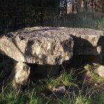
- The burial chamber in the Phoenix Park. Pip Powell.
-
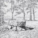
- Drawing of Knockmaree by William C. Borlase
The Early Medieval to Viking Period
Aerial photography taken by the late Leo Swan, in the area of the Fifteen Acres, reveal circular and linear earthworks. These may reflect early medieval settlements or farmsteads known as ringforts. These settlements commonly date from 500 to 1100 AD. Alternatively these earthworks may be the result of intensive use of the Park for military exercises.
Evidence for the Viking period is notable in the area of the park. Gravel excavations into the banks of the Liffey at Kilmainham and Islandbridge in the 1840’s and 1850’s and again in the 1930’s revealed 40 graves. This is the largest Viking cemetery found outside Scandanavia. One of these graves, an outlier to the cemetery proper is recorded as being within the Phoenix Park. The grave contained the remains of a woman with a pair of bronze oval Scandanavian brooches one of which was attached to a gilt bronze mount. The brooches are datable to the 9th or 10th century. The decoration on the mount has been interpreted as dating to the first half of the 8th century. This burial was found near the Wellington Testimonial in 1876 but the archaeological context of these finds was not fully recorded.
Medieval to Post-Medieval
In 1177, Hugh Tyrell, Baron of Castleknock, granted lands at Kilmainham to the Priory of St. John of Jerusalem (Knights Hospitallers). The grant included a portion of the land that now makes up the Phoenix Park in addition to the lands to the south of the Liffey stretching to the present site of Kilminaham Goal.
At the time of the Dissolution of the Monasteries in 1542, the priory’s lands and hospital were confiscated by King Henry VIII. South of the river the priory appears to have been used as a viceregal residence during the reigns of successive sovereign.
Ashtown Castle is the oldest building in the Park. It is a tower house or fortified dwelling which may date from as early as the 1430’s as it is built to dimensions which conform to a grant for the construction of castles at that time. The tower is three stories high and is constructed of limestone rubble masonry. It has a square turret on the south-east side and a gable and surmounted by a chimney at the east side. The window opes are simple and flat-headed and a blocked door ope is visible on the northern side of the building. Timbers within the roof have been dated to the early 1600’s but this may represent a phase of rebuilding. Around 1760 the castle was incorporated into a larger Georgian house (Ashtown Lodge) which was since demolished.
In 1609 Sir Richard Sutton was granted the castle at Kilmainham and surrounding lands and by 1611 he had assigned this land to Sir Edward Fisher. Fisher’s lands included all lands north of the Liffey from Oxmantown to Chapelizod which comprised 330 acres of the Kilmainham castle demesne and 60 acres known as Kilmainham Wood. Sir Edward erected a country house at Thomas’s Hill believed to have once been known as Isolde’s Hill. The house was named “ Phoenix”. In 1618 Fisher surrendered his lands to the King. The Crown purchased additional lands at Chapelizod, Grangegorman, Castleknock and Ashtown. These lands form the core of the park. The “Phoenix” was used as a viceregal residence up to 1665. The house was demolished in 1734 to make way for the powder magazine or Magazine Fort.
The buried remains of a star-shaped fortification may survive buried beneath the sod to be rediscovered by archaeological investigations. It was constructed in the early part of the eighteenth century at the Dublin Gate in the south-east end of he park. In September 1834 a number of improvements were made to the Park under the direction of Decimus Burton including the levelling and in-filling of the star-shaped fort and underground drains which replaced open drains. The Ordnance Survey 1837 map shows part of this fort which is labelled as ‘old star fort’. Currently there are sports grounds on the site.
The idea of forming a deerpark was first considered by Lord Falkland in the early seventeenth century. In 1623 a reference is made relating to a proposed Royal Park concerning an individual employed by “Royal command in His Majesty’s park which was to be enclosed near Dublin for game and breeding of deer”.
-
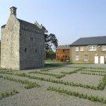
- Phoenix Park, Dublin City, Ireland
-
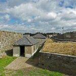
- The Magazine Fort, Phoenix Park, Dublin.